
Open User Map
Let your community build and maintain an interactive map together with Open User Map's simple frontend submissions and approval workflows.
Visit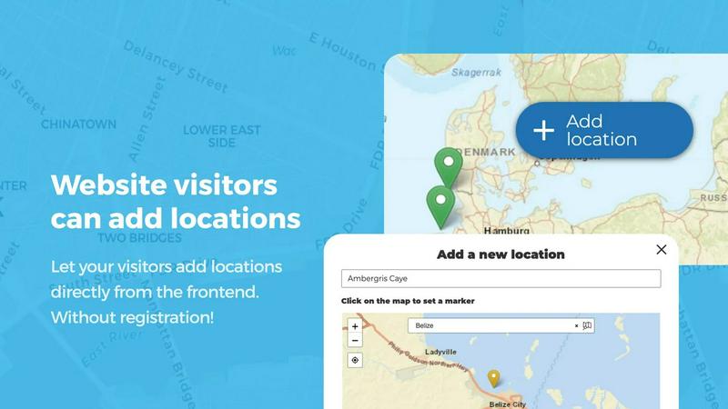
About Open User Map
Open User Map is a powerful interactive map plugin for WordPress that allows you to create a collaborative, community-driven map experience without any coding or technical complexity. Our team designed this tool to bridge the gap between website owners and their visitors, enabling a seamless two-way flow of location-based information. At its core, Open User Map lets your website visitors add and edit locations directly on your map through an intuitive frontend interface. Every submission goes through an approval workflow, ensuring you maintain full control over what appears on your map. This plugin is perfect for community directories, tourism guides, real estate listings, event maps, and any scenario where user-generated location data adds value. What makes Open User Map truly special is its commitment to simplicity and accessibility. There is no need for a Google Maps API key, no complex setup procedures, and no coding knowledge required. With over 15,000 active installs and a perfect 5-star rating, our community of users has proven that collaborative mapping can be both powerful and easy to implement. We focus on synergy between website owners and their audiences, creating a cooperative ecosystem where everyone contributes to building a richer, more accurate map. Whether you are running a local business directory, managing a tourism website, or organizing a large event, Open User Map provides the tools you need to harness the collective knowledge of your visitors.
Features of Open User Map
Frontend Location Submissions and Editing
Enable your website visitors to add and edit locations directly on your map through a simple, user-friendly frontend interface. When a visitor clicks the Add location button, they can place a marker and submit detailed information, which then enters an approval workflow for your review before going live. Users can also edit their existing locations, ensuring the map always reflects the most current and accurate information. This collaborative approach empowers your community to actively participate in building and maintaining your map, creating a shared sense of ownership and cooperation.
Advanced Categorization and Filtering
Organize your map markers into distinct categories, each with unique icons, to create a clear and visually appealing layout. This feature allows visitors to filter locations by category, making it easy to find exactly what they are looking for. For added flexibility, each location can belong to multiple categories, ensuring that all relevant attributes are represented. Our team has designed this system to work synergistically with your content strategy, helping you present complex location data in an intuitive and accessible way that encourages exploration and discovery.
Lines and Areas Mapping
Go beyond simple location markers by adding routes, paths, zones, and regions directly to your map. This feature lets you highlight trails, service areas, event grounds, neighborhoods, construction zones, or any custom shape that helps visitors understand your map at a glance. Distances and area sizes are calculated automatically, so routes and polygons include helpful measurements right out of the box. This capability is perfect for collaborative projects where multiple users need to visualize boundaries, pathways, or designated zones, fostering a team-oriented approach to map building.
Custom Image as Map
Upload any image and transform it into a fully interactive map, whether it is an overlay, floor plan, event layout, game map, product diagram, campus guide, or seating chart. Users can place markers directly on top of the image with the same powerful functionality as a traditional map. You can add locations, display custom fields, enable filtering, and create an engaging, clickable experience tailored exactly to your use case. This feature opens up endless possibilities for creative collaboration, allowing your community to interact with visual content in entirely new ways.
Use Cases of Open User Map
Community-Driven Local Business Directory
Create a comprehensive local business directory where residents and visitors can add their favorite shops, restaurants, and services. Users submit business details, including hours of operation, contact information, and categories, which you can approve before they appear on the map. The star rating and upvote features allow the community to highlight the best places, creating a cooperative ecosystem where everyone benefits from shared knowledge. This collaborative approach ensures your directory stays current and relevant without requiring constant manual updates from your team.
Tourism and Travel Guide Map
Build an interactive travel guide where tourists can share hidden gems, popular attractions, and local recommendations. Visitors can add points of interest like hiking trails, scenic viewpoints, and cultural landmarks, complete with descriptions and photos. The lines and areas feature lets you highlight walking routes, bike paths, or neighborhood boundaries, helping travelers navigate unfamiliar areas with confidence. By working together with your audience, you create a dynamic and trustworthy resource that evolves with every visitor contribution.
Event and Festival Mapping
Organize large events or festivals with a collaborative map that allows attendees to find vendors, stages, restrooms, and parking areas. Use the custom image as map feature to overlay a venue floor plan or site layout, enabling visitors to place markers for specific booths or activities. The approval workflow ensures that only verified information appears, while the filtering interface helps attendees quickly locate what they need. This cooperative tool enhances the event experience by putting the power of location sharing directly into the hands of your attendees.
Real Estate and Property Listings
Create a collaborative real estate map where agents, homeowners, and potential buyers can add and explore property listings. Each listing can include custom fields for price, square footage, bedrooms, and other important details. The regions feature allows you to define neighborhoods or districts, making it easy for users to filter properties by area. The upvote and rating system helps highlight the most desirable properties, fostering a cooperative marketplace where everyone contributes to a more informed and efficient property search.
Frequently Asked Questions
Do I need a Google Maps API key to use Open User Map?
No, you do not need a Google Maps API key to use Open User Map. Our team has designed the plugin to work seamlessly without any external API keys, eliminating a common headache for WordPress users. This means you can get your interactive map up and running in minutes without dealing with complex setup procedures or worrying about API usage limits. The plugin handles all mapping functionality internally, providing a smooth and hassle-free experience for both you and your website visitors.
How does the approval workflow work for user submissions?
When a website visitor submits a new location or edits an existing one, the submission enters a pending state that requires your approval before it becomes visible on the map. You will receive notifications about pending submissions and can review each one from your WordPress dashboard. This workflow gives you full control over the content that appears on your map while still encouraging community participation. You can approve, reject, or edit submissions as needed, ensuring that only accurate and appropriate information is published.
Can I customize the look and feel of my map?
Yes, Open User Map offers powerful customization options to match your brand and website design. You can choose from different map styles, customize marker icons and colors, and add custom fields to collect specific information from users. The plugin also supports custom HTML content sections in the filter sidebar, allowing you to display additional information or branding. Our team has focused on making customization intuitive and accessible, so you can create a map that feels like a natural extension of your website without any coding knowledge.
Is Open User Map compatible with other WordPress plugins and themes?
Yes, Open User Map is designed to work harmoniously with most WordPress themes and plugins. Our development team has tested the plugin extensively with popular page builders, caching plugins, and SEO tools to ensure broad compatibility. The plugin follows WordPress best practices and uses standard hooks and filters, making it easy to integrate with your existing workflow. If you encounter any compatibility issues, our support team is ready to help you find a collaborative solution that works for your specific setup.
Similar to Open User Map

WTAgent
Turn ChatGPT Web into Codex and Claude Web into Claude Code. Open-source CLI coding agent - no model API key needed.
Getastrothemes
Premium and free Astro themes for SaaS, startups, agencies, and businesses, built for speed, SEO, and easy customization.
Uptimepage
Watch your sites and APIs from several regions, page the right person when one breaks, and keep customers informed on a status page. Free plan.
Intlayer
Intlayer lets teams define translations alongside components, ensuring type safety, AI-powered localization, and visual editing through a.

OriginBrief
OriginBrief delivers weekly, source-backed reports that monitor key developments in your chosen topics, ensuring you focus on what matters.
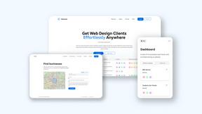
Webleadr
Webleadr helps your team effortlessly find and contact businesses without websites, turning them into web design clients together.

Idearium
We partner with you to craft memorable websites that grow your business.

FilexHost
Easily host and share your files in seconds with secure links and built-in viewers for seamless collaboration.