
GeoRank
GeoRank lets you explore, compare, and rank places worldwide on sunshine, cost, tax, and visa access, then ask AI for relocation insights.
VisitPublished on:
July 13, 2026
Pricing:
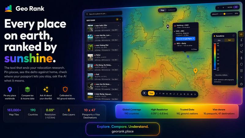
About GeoRank
GeoRank is a free, no-signup interactive map tool designed to transform the way you research and decide on your next place to live, work, or travel. Instead of juggling a dozen separate websites for weather, cost of living, taxes, visas, and safety, GeoRank layers eight critical data sets onto a single global grid with a resolution of approximately 5 kilometers. This platform is built for digital nomads, remote workers, expatriates, and anyone considering a significant relocation or extended stay abroad. Its core value proposition is moving you from scattered browsing to a structured, data-driven decision. By pinning up to 20 candidate locations, you can compare every metric against your current home base to see exactly where you will be warmer, cheaper, safer, or taxed differently. A unique AI assistant then reasons exclusively over your personal shortlist, answering complex questions like "Which of my places has the best winter?" with cited, grounded answers. GeoRank ends the chaos of relocation research by bringing all the critical data into one collaborative, synergistic workspace where you and your team can explore, compare, and understand every aspect of a potential move.
Features of GeoRank
Explore with 9 Live Data Layers
GeoRank provides a comprehensive suite of nine toggleable data layers that you can stack and explore simultaneously. These layers include sunshine hours calibrated against 182 ground stations, temperature data from ERA5 and CHELSA, rainfall, outdoor hours, tax rates sourced from OECD, PwC, and KPMG, visa and residency routes across 47 destinations for 10 passports, cost of living from 478 cities, geopolitical risk, and community-sourced "Nomad Pulse" sentiment. This collaborative integration of diverse datasets allows you and your team to see the full picture of any location at a glance, fostering a cooperative understanding of the tradeoffs involved in your relocation.
Pin, Compare, and See the Delta
This feature enables you to click any location on the map and pin it to your personal shortlist, saving up to 20 places across sessions. Once pinned, you can switch to Compare mode and set your current home as a baseline. Every metric for your pinned locations is then presented as a delta, or a difference, from your home base. You can see exactly how many more sunshine hours a place offers, how much cheaper it is, or how its tax rate compares. This relative comparison, rather than just absolute numbers, builds a shared understanding of how each candidate location stacks up against your current reality, making team discussions more focused and productive.
AI Assistant for Your Shortlist
The AI chat feature operates exclusively on your pinned locations, not a generic knowledge base. When you ask a question like "Which of my 5 places has the best winter?" or "Score my shortlist for sunshine, cost, and low tax combined," the AI reasons across all the specific data for your chosen places. It provides grounded, cited answers that compare metrics directly, such as showing that Paphos meets a sunshine threshold while Tbilisi does not, but Tbilisi is considerably cheaper. This synergistic interaction allows you and your collaborators to quickly explore complex, multi-variable questions without manually cross-referencing data, turning raw information into actionable insights.
Calibrated Data for Ground Truth
Unlike many tools that rely solely on raw satellite data, GeoRank prioritizes accuracy by calibrating its models against ground truth. For example, the sunshine layer merges SARAH-3 satellite observations with ERA5 reanalysis data, then bias-corrects the result against 182 ground stations from locations like Reykjavik, Phoenix, and Sydney. Orographic terrain corrections are applied to account for high-altitude and coastal microclimates. This commitment to precision ensures that the data you and your team rely on is trustworthy and reflective of real-world conditions, enabling more confident and collaborative decision-making.
Use Cases of GeoRank
Relocation Research for Remote Workers
A remote worker considering a move from New York to either Lisbon or Chiang Mai can use GeoRank to make a data-backed decision. They pin both cities, set New York as their home base, and immediately see the delta in cost of living, sunshine hours, and tax rates. They can then ask the AI, "Which city has a lower tax burden for a US citizen freelancer?" The AI will compare the specific tax treaties and residency rules for both locations against the user's passport, providing a clear, cited answer. This use case transforms a daunting research project into a structured, collaborative exploration with a clear outcome.
Family Relocation Planning
A family with school-aged children looking to relocate from London to either Paphos or Tbilisi can use GeoRank to evaluate tradeoffs beyond just cost. They can compare sunshine hours for outdoor activities, geopolitical risk scores for safety, and cost of living for family expenses. Using the AI, they can ask, "What are the tradeoffs between Paphos and Tbilisi for a family?" The AI will summarize the differences in safety, educational infrastructure implied by cost-of-living data, and visa duration for their passports. This collaborative tool allows all family members to see the same data and discuss priorities in a structured way.
Strategic Business Relocation
A startup founder exploring where to establish a legal presence for their team of ten can use GeoRank to evaluate multiple jurisdictions. They can pin locations like Tallinn, Dubai, and Austin, and compare corporate tax rates, personal income tax for employees (based on passport data), and cost of living for the team. The AI can answer complex questions like, "Which location offers the best combination of low corporate tax, affordable housing, and high sunshine hours for my team?" This synergy of data layers helps the team reach a consensus on a location that balances business needs with employee quality of life.
Retirement Destination Scouting
A couple planning their retirement in a warmer climate can use GeoRank to narrow down their options from a shortlist of five cities. They can compare sunshine hours, temperature, cost of living, and geopolitical risk. By asking the AI "Which of my pinned places is best for a winter base?" they get a comparative analysis of winter conditions across their shortlist. The tool also helps them check visa duration for their passport, ensuring they can stay long-term. This use case demonstrates how GeoRank helps users move from a broad list of possibilities to a confident, data-driven final choice.
Frequently Asked Questions
Is GeoRank really free to use with no signup?
Yes, GeoRank is completely free to use and does not require any signup or account creation. You can access the interactive map, toggle all nine data layers, pin up to 20 locations, use the Compare mode, and ask the AI questions about your shortlist without any cost or registration. This open access allows you and your team to start your relocation research immediately.
How accurate is the data on GeoRank?
GeoRank prioritizes accuracy by calibrating its data against ground truth sources. For example, the sunshine data is bias-corrected against 182 ground stations from diverse climates like Reykjavik, Phoenix, and Sydney. Temperature data uses ERA5 and CHELSA models. Tax information comes from OECD, PwC, and KPMG databases. Cost-of-living data is sourced from 478 cities. While no global dataset is perfect, GeoRank's methodology provides a high level of reliability for decision-making.
How does the AI assistant work?
The AI assistant on GeoRank is designed to reason exclusively over your pinned locations and their associated data. It does not rely on a generic knowledge base. When you ask a question like "Which of my 5 places has the best winter?" the AI analyzes the specific temperature, sunshine, and rainfall data for each of your pinned places. It then provides a comparative answer with citations from the GeoRank data layers, helping you understand the tradeoffs between your shortlisted locations.
What data layers are available on the map?
GeoRank offers nine live, toggleable data layers: Sunshine, Temperature, Rainfall, Outdoor Hours, Tax, Visas and Residency, Cost of Living, Geopolitical Risk, and Nomad Pulse. Each layer is a distinct dataset that you can turn on or off independently. You can stack multiple layers to see how different factors overlap in a specific region, providing a comprehensive and synergistic view of any location on the map.
Similar to GeoRank

Wheel of Names Picker AI
Wheel of Names Spin Wheel Picker tool for classrooms or events
CareerJump
A free personalized weekly newsletter to help you keep up with developments relevant to your career.
RunMyWealth
Free, private financial calculators for mortgage, FIRE, and debt. 100% free, runs locally in your browser, no signup required.


mcpfolio
Discover MCP servers, compare tools, and follow setup guides to connect AI assistants to your apps and workflows

Riff
Riff writes replies, DMs and posts with Gemini Nano inside Chrome. Runs on your computer, no account or API key, and never posts for you.
Novastart
Apps and files on an infinite canvas where people and AI agents work together.

Snapkin
Snapkin is a calorie tracker you use by photographing your plate.